Battlefield Management Software is a fancy title for a piece of publicly available software which allows milsim games to have that extra degree of reality.
Now it has to be said that the Slovenian maker is a real defence company which produces different flavours of this software depending on whether you are a mountain hiker, milsim player, Security/LEO or the military.
What Does It Do ?
It's similar to a Blue Force Tracking software except it has a few enhancements which allow it to do some extra stuff like navigation, past tracking of forces, interfacing to laser rangefinders and so on.
Easier to show you..
You can download a wide variety of free mapping, but this example shows Google Earth.
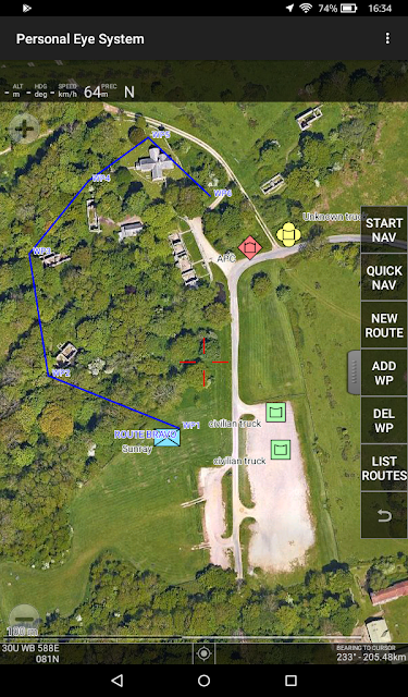
For this example, I am showing a milsim game in the British Army Training Village of Tyneham in Dorset (I know, we can dream).
The Blue (BLUFOR) unit is us, callsign SUNRAY. The software is showing us two civilian trucks in green, an enemy APC in red and an unknown vehicle in yellow (this follows NATO symbology doctrines for friend or foe). These objects have to be manually entered by us or one of our allies on the same net, but it means that everybody is looking at the same scenario and we then all know the same information.
So far so good.
What do I need to run this and how much does it cost ?
Well the bad news (for iPad and iPhone owners anyway) is that the Personal Eye System only runs on Android operating systems. In saying that, Apple products are probably far too valuable to expose to airsofting ?
I found that the Amazon Kindle Fire 7 made a great rugged tablet for milsim use. With its 7" display and ruggedised case, it cost £64 from Amazon. You will need to load Google Play Store on to it as the Amazon app store doesn't sell PES. You will still need your mobile phone to act as a wifi hotspot as the tablet doesn't have data connectivity, but you can use your regular smartphone and bury it deep in your kit so it doesnt get broken. All user interaction is done through the tablet and let's face it, only one player in each squad or fireteam really needs a PES enabled tablet on behalf of their team - this is usually the TL/SL or RTO.
Edited to add - the Kindle system is a pain and I struggled to get my smartphone to provide its GPS position to the Fire 7. In the end, I connected it by bluetooth to my Garmin GLO cigarette packet GPS and by wifi to my phone hotspot. The Garmin is fast and works on both the US and Russian satellites. However, it's probably easier to just load the PES software on an Android smartphone with its own integral GPS rather than faff about with the Kindle flavour of Android.
In terms of operating costs, the organiser or team leader needs to buy the PES military app which is £12 and then have a PES server subscription which is Euro 4.80 per month for 10 users (or Euro 48 per annum). Players wishing to be on the net are then invited to use a free version of the app and join the network using a PIN that the organiser or team leader will give you. There are lots of purchase options for this application and its use and I won't go into them all here (check out their website which I will post a link to at the bottom).
My experience of this kind of software is that due to the low volume take up/niche market, most developers go in too cheap to attract players and then can't afford to maintain the software. The makers of PES, Mil Sistemika are a resourced defence company and make a reasonable charge for the application and its maintenance.
Other Features
Here you can see that SUNRAY has plotted an indirect flanking action (blue route line) around the back of the buildings to come up behind the enemy APC. Using the fly-out menu on the right, anybody on the net can create a new route and add waypoints to show all the allied units how they will approach.
COP stands for Common Operational Picture and is effectively what is shared between users over the net. The COP list is a list of all the assets in the COP.
You will also notice that the top line (just below the words Personal Eye System) shows own position which is derived from your phone triangulation or its inbuilt GPS if it has one.
Towards the bottom of the screen is a black text line which displays chat between units. Any user can send a message to other units using secure datacomms (only visible by those using the same PIN number).
Here we have chosen for only one line of chat to be visible to maximise the mapping space but users can adjust this up to 4 lines in settings.
If you press the three vertical dots shown in the top right hand side of the screen, you get the drop -down settings menu. You can elect to have the software update your COP at preset intervals or you can manually update (sync COP picture) at times when you wish to conserve data or work between data dead zones.
Website: Mil Sistemika


