Originally developed around 2001 to enable forces to know the location of other friendly forces (presumably to avoid friendly fire incidents), it was also used to identify the suspected or observed location of enemy forces.
BFT usually comprises of a processor running bespoke software and which is connected to a military GPS for position reference and a tactical radio or satellite terminal for the sharing of encrypted data over the battlespace.
Initially fitted to military vehicles as a PC-based installation, improved battery technology and the reduction in the size of modern electronics, has enabled BFT to become a personal tool for the battlefield soldier, running on a portable ruggedised tablet.
As well as allowing the avoidance of friendly fire, BFT permits commanding officers to know the positions of their forces, direct them to desired locations using mapping on the screen and to communicate with them using text messaging.
BattleTac is a Hungarian software company which has developed a version of BFT for military gaming use.
The BT software can run on a smartphone or tablet using iOS or Android operating systems. The host platform used in gaming, just like the real BFT, needs to have a position reference which can be derived from an internal GPS or cell triangulation using the mobile network and it needs to have a data connection via GPRS, 3G/4G, etc.
In practice, an inexpensive smartphone can be used for personal use at a milsim (I have an LG one which cost £50 from Tesco). More expensive phones offer bigger screens to make mapping clearer but are more vulnerable and a bigger monetary loss if damaged in the field. Battlefield commanders who observe and manage their forces from relative safety often use a larger tablet to view proceedings.
 |
| Screenshot of BattleTac from Tablet |
As the operation of such a system can be difficult in the field, players can choose just to be tracked (by burying their smartphone in the relative safety of a pouch or bergen) and this means that their commander will know their location as they move around. The commander can use this positional information to direct them by normal radio commands. How often have you been asked for your position over the radio by Command, only to find that one tree looks much like another in woodland and you really aren't sure. This call becomes unnecessary with BattleTac tracking and the position that the C.O sees is much more accurate that your estimation could ever be !! Not only does this remove errors from poor verbal communication but it frees up the player to concentrate on the enemy rather than radio requests for updated positions.
Sometimes, Squad or Team Leaders will carry a small tablet in a ruggedised case. This enables them to reach a place of reasonable safety out of a potential contact situation and consult the tactical situation on the screen while the rest of the squad provide him with cover.
Imagine that your squad are dug in on the top of a hill overlooking an enemy position. You want to call in an airstrike or ARTY barrage. The SL can take out his tablet and identify the position of the enemy encampment by clicking on the mapping - much easier than sending grid references verbally.
Its also a boon for recon units as they can stay completely stealthy. Radio calls are noisy and can be intercepted. The recon unit can send everything using encrypted data.

In a scenario where you are attacking an enemy dam installation, the commander can indicate the position of the respawn point and an enemy position to avoid in a nearby farm.
Own forces have indicated here that they are wounded, by changing their status from the green "in-game" to the orange "wounded".

There is a text communication mode called CHAT which allows the user to select the mode on a drop down menu and type using the virtual on-screen keyboard. As you can see here "Alpha" are communicating with the commander indicating that they have been hit and requesting he directs another unit to make the attack on the dam.
The benefit of CHAT is that all units can see the communication but it is otherwise secure and obviously silent, so it doesnt give away your position if the enemy is nearby.

Mapping can be downloaded at home on broadband internet and stored in the memory of the smartphone or tablet, which reduces the data bandwidth needed in the field. Some organisers make custom maps in .kmz format which are stored on the BattleTac server and can be downloaded for free before you leave home.
This means that the only data being passed in the field is for positions being exchanged and text messages and these are very small amounts of data.

This is how BattleTac looks on a small smartphone. How often have you seen movement through the trees or a gap in the buildings and aren't sure if you are firing at the enemy or your own troops ?
This is especially puzzling when the loadouts of the teams aren't that different when viewed from a distance !!!!
BattleTac can help solve the confusion and protect against friendly fire..

THE THREE DROP DOWNS (AKA MENUS)
The menu controls are quite easy to work, even with a small screen.
There are three menu-style drop-down buttons; MENU, CHAT and a pipper shaped button to open the menu which allows the transmission of information.

MENU
Primarily for setting up things like your radio channel number, your team security code for encryption and your identification symbol/callsign etc.

and if you scroll down this menu list further:
Organiser View, as the name suggests, allows a game organiser to view both teams and all datacomms traffic on their game overview monitor screen (if this is required within the dynamic of the game). The organiser will need your consent and team password to achieve this so it's at the discretion of the teams themselves, not at the control of the game organiser (no big brother). If your smartphone has a built in compass, this can also be displayed on your screen to allow you to calculate heading, bearings etc when working with your screen mapping.

CHAT
As already mentioned, users can exchange data messages which is useful when the radio audio is too noisy to be used in your position (too near the enemy), there is bad reception/static or your radio channels have been compromised by the enemy scanning them or capturing one of your radio units.
The example below shows a conversation exchange between two BLUFOR units, complete with time stamps.
To save time, you can type your own "often used" messages into the templates section and they can be recalled to save typing time in the field.

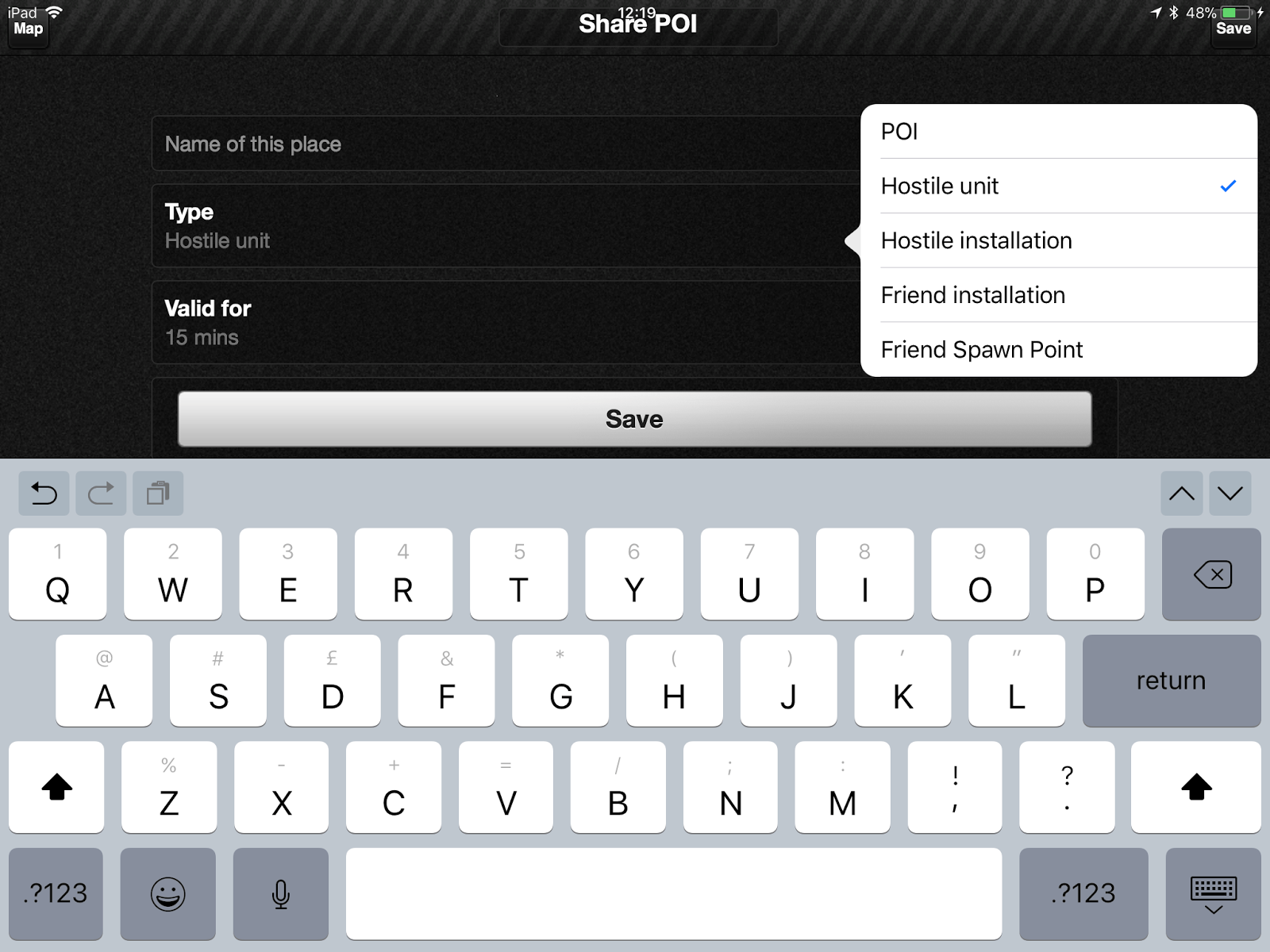
MARK THIS PLACE/TRANSMIT INFORMATION
The Transmit Information Pipper or "Mark this place" menu allows the user to share Points of Interest (e.g. enemy movements or installations), set geographical points as a destination (e.g for RVing) and allows the commander to despatch a unit to a certain point.
In a GPS denied environment, you can also manually mark your position and transmit it to everybody else (if you are pretty sure where you are !!!).

The "Sharing POI" sub-menu allows the user to share geographical locations using markers or to indicate hostiles, friendly assets etc. It's possible to set these objects with time expiry times, which is useful if you know that camps will be struck, vehicles will move after a while etc or you just dont want to clutter the mapping for others once a task is completed.